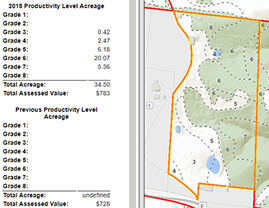
To view parcel-level land grade acreage information for agricultural properties, zoom/pan to the parcel of interest and left click to open the details popup.
On a mobile device, search results will be available in the Data tab. On the Map tab you can view the property or use the map tools.
Data sources: Soils: USDA-NRCS Soil Survey Geographic Database (2011 SSURGO from websoilsurvey.sc.egov.usda.gov), Parcel & Forest: Boone County Assessor. Road Centerlines, Structures, & Hydrology: Boone County and City of Columbia. For Boone County GIS dataset disclaimers, please visit the GIS data disclaimers page.